Dashboard ·
Mangroves and protected areas
Mangrove extent inside and outside protected areas, 1985 to 2025, by country.
Global Mangrove Watch ( ) maps mangroves yearly from 1985 to 2025. Researchers at Aberystwyth University and use publicly available and satellite images alongside radar observations. Their maps show changes in mangrove extent along coasts worldwide.
The World Database on Protected Areas ( ) records the boundaries of protected areas worldwide. The data is supplied to them by governments and other organisations. and bring them together globally.
This dashboard overlays the WDPA protected areas on the GMW mangrove extent for every year from 1985 to 2025. It measures how mangrove cover changed over time inside and outside protected areas.
Contents
- The global picture
- Does the type of protection matter?
- Three protected areas over time
- Compare countries
- Explore the map
- Notes
- References
- Data sources
The global picture
In 2025, GMW mapped about 151,000 km² of mangrove worldwide. That is 1,900 km² less than in 1996, a net loss of 1.3%. Cover did not fall steadily. It reached a low in 2004, recovered by 2009, then fell to a second low in 2014. From 2015 to 2025 it grew by about 1%. Cover in 2025 was about 0.3% greater than in 1985.
The charts and figures below show cover and change over time. Use the dashboard controls to change the time period, and the toggles on the charts to switch views and see gains and losses against the baseline.
- Lost
- —
- Gained
- —
Global mangrove cover
Does the type of protection matter?
The WDPA records a management category for many protected areas. Here, categories Ia, Ib and II form the strict reserves.1 Categories III to VI form managed reserves. Areas without a reported category have their own group. The chart compares mangrove loss inside these groups and outside protected areas.
Gross loss rate by protection type since 1996
From 1996 to 2025, loss inside protected areas was lower than outside them, and strict reserves had the lowest loss rate of any group. This does not mean strict reserves protect mangrove better. Protected areas tend to be placed in remote places that would face less clearing anyway.2
Three protected areas over time
Loss does not necessarily mean deforestation. Erosion, storms and shifting sediment can remove mangrove. Gains may come from sediment, regrowth or planting.
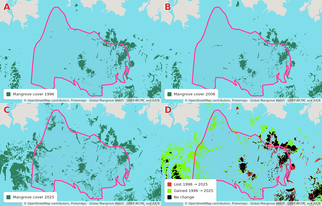
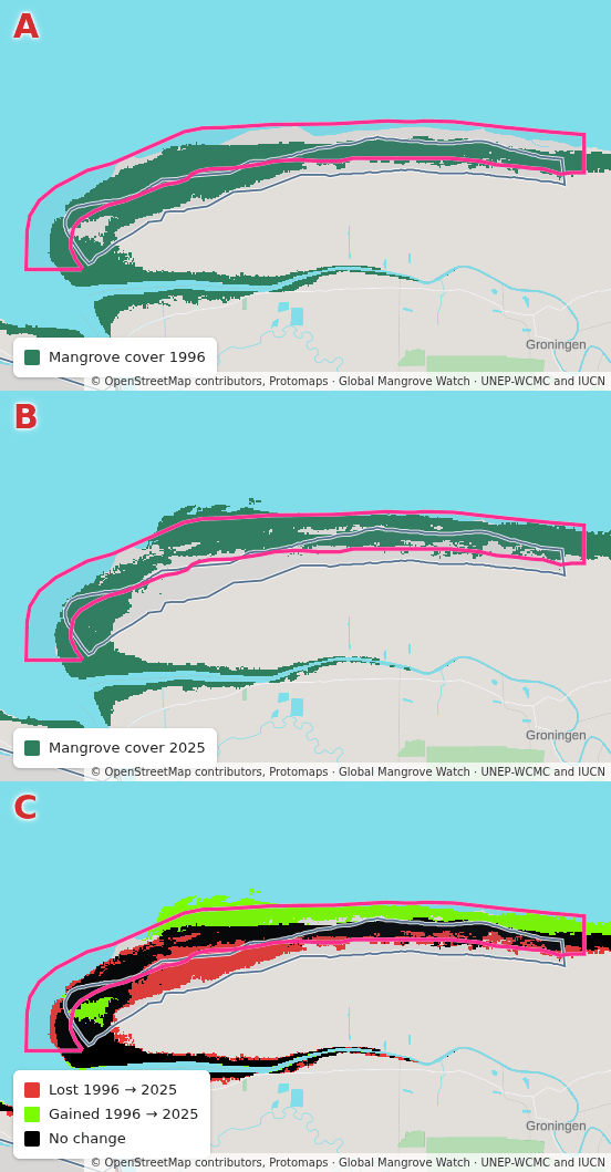
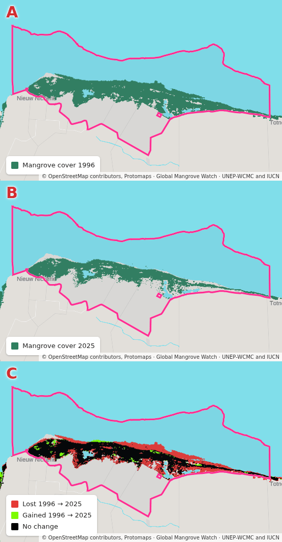
The following animations show how mangrove changed over time in three protected areas. For example, Keti Bunder South had 52% more mangrove in 2025 than in 1996. In Suriname, Coppename Monding gained 14%, while Bigi Pan lost 46%. Use the map below to explore this for yourself.
Compare countries
Indonesia holds about 21% of the world’s mangrove but protects only 8% of its own. Bangladesh has 92% inside protected areas and almost no net change since 1996. Pakistan has 32% inside protected areas and gained 81%.
Of the 110 countries with mangrove in 2025, 42 have less than 30% [1] inside protected areas. The international concerns land and sea conservation.
- In 1996
- —
| Country | Mangroves, 2025 | Protected share, 2025 | Change since 1996 | Share of global loss since 1996 |
|---|
Explore the map
Choose a year and a baseline from the dashboard controls to view mangrove change between those years. The figures, charts and map on this page follow those choices. Toggle the map button to Changes to show loss (red), gain (light green) and unchanged mangrove (black). Blue outlines mark the protected areas established by the chosen year.
Search the map for a country, then select a protected area to view more details. The charts under the map show how cover changed over time in the country and in the selected protected area. Search for Suriname, then select Bigi Pan or Coppename Monding to see the changes from the animations above.
- Suriname
- Mangrove cover 2025
Suriname
Pick a protected area on the map to chart it here.
Notes
- Strict reserves are IUCN Ia, Ib and II, the grouping of Joppa and Pfaff (2009). The IUCN guidelines rank no category above another. ↩
- Joppa and Pfaff (2009) found that protected areas worldwide lie disproportionately on land that is high, steep and far from roads and cities, where clearing is less likely. ↩
References
- Convention on Biological Diversity (2022). Kunming-Montreal Global Biodiversity Framework, decision 15/4 of the Conference of the Parties. CBD/COP/DEC/15/4. https://www.cbd.int/doc/decisions/cop-15/cop-15-dec-04-en.pdf
Data sources
Show the 9 sources
- Global Mangrove Watch: Timeseries of Mangrove Extent, version 4.1, Aberystwyth University and soloEO, for the Global Mangrove Alliance, version 4.1.12, CC-BY-4.0
- World Database on Protected Areas, UNEP-WCMC and IUCN, version 2025-12, Protected Planet Terms and Conditions
- OpenStreetMap planet snapshot, OpenStreetMap contributors, version 2026-08-17, ODbL-1.0
- Natural Earth vector, GeoPackage package, Natural Earth, version 5.1.2, public domain
- Coastline water polygons, split, Mercator, osmdata.openstreetmap.de, version 2026-08-25, ODbL-1.0
- Land polygons, split, Mercator, osmdata.openstreetmap.de, version 2026-08-25, ODbL-1.0
- Daylight landcover, vectorised, Protomaps, from the Daylight Map Distribution, version 2026-08-24, CC-BY-4.0
- Wikidata QRank, Sascha Brawer, on Wikimedia Toolforge, version 2026-08-24, CC0-1.0
- Positioned Glyph Font encodings, wipfli, version 2026-08-24, MIT